
How Self-Driving Cars See in Real Time
In real time, a self-driving car's perception system ingests gigabytes of raw data from cameras, radars, and lasers, transforming this sensory noise into a highly structured, three-dimensional understanding of the physical world. This data is instantly fed into advanced neural networks - either through a step-by-step modular pipeline or a unified, end-to-end artificial intelligence model - that predict the movements of surrounding objects to execute immediate steering and braking commands. To achieve superhuman safety, this entire perception-to-action cycle must execute flawlessly in a fraction of a second, navigating a delicate balance between computational limits and the unpredictable chaos of public roads.
The autonomous driving industry has reached a critical technological and commercial inflection point. As of early 2026, companies like Alphabet's Waymo and China's Baidu are operating vast commercial robotaxi fleets across major global cities, while consumer-grade advanced driver-assistance systems (ADAS) are pushing the boundaries of conditional autonomy 123. Yet, despite billions of miles driven in simulation and reality, the core technical challenge remains the same: how to teach a machine to instantly perceive, interpret, and navigate a highly fluid physical environment. Understanding how a self-driving car "sees" requires looking deeply into its perception pipeline - a complex, real-time symphony of hardware sensors, data fusion algorithms, and artificial intelligence.
The Race Against Time: Latency and the 100-Millisecond Budget
For a human driver, perceiving a sudden road hazard and initiating a physical response - such as moving a foot to the brake pedal - takes an average of 0.96 to 1.64 seconds 1. For an autonomous vehicle, this human-level delay is unacceptably dangerous. At highway speeds of seventy miles per hour, a one-second delay means the vehicle travels more than one hundred feet before it even begins to react to an obstacle 1. Consequently, autonomous systems are engineered to operate within an incredibly strict "latency budget." To safely navigate dense urban environments and react to unpredictable events, the end-to-end processing pipeline - from the moment a photon hits a camera lens to the moment the vehicle's actuators apply the physical brakes - must complete in less than 100 milliseconds 152.
Managing this immense computational load without bottlenecking the system is one of the most significant challenges in autonomous robotics. A modern autonomous vehicle sensor suite generates approximately one gigabyte of raw data every single second 1. High-resolution cameras, such as those capturing images at 1280 by 1920 pixels, provide the necessary detail to read distant traffic signs, but running complex object-detection algorithms on these full-resolution images can take over 100 milliseconds on its own, instantly exhausting the latency budget 2.
To mitigate this computational bottleneck, engineers divide the driving task into specialized, parallel algorithmic threads that "tick" at different frequencies. Low-level physical systems, such as Inertial Measurement Units (IMUs) and the steering and braking actuators, operate at incredibly high speeds, often ticking at 50 to 100 Hertz, meaning they update every 10 to 20 milliseconds to maintain physical stability 5. The core perception stack, which handles object detection and lane mapping, alongside the motion planner, typically operates at a slower rate of around 10 Hertz, updating once every 100 milliseconds 5. Meanwhile, Vehicle-to-Infrastructure (V2I) communication - such as querying the status of an upcoming traffic light over a 5G network - can tolerate latencies of hundreds of milliseconds to a full second, as this data is utilized for long-range behavioral planning rather than split-second collision avoidance 5.
Developers also rely on highly optimized edge computing hardware, sophisticated deep learning accelerators, and specialized networking protocols like Time-Sensitive Networking (TSN) to prioritize critical data packets over the vehicle's internal wiring harness 27. Furthermore, recent advancements have introduced multi-resolution convolutional neural networks that dynamically select the optimal image input scale based on the current scene context, thereby balancing accuracy with the strict latency budget required for survival 8.
The Hardware Suite: Reconstructing the Physical World
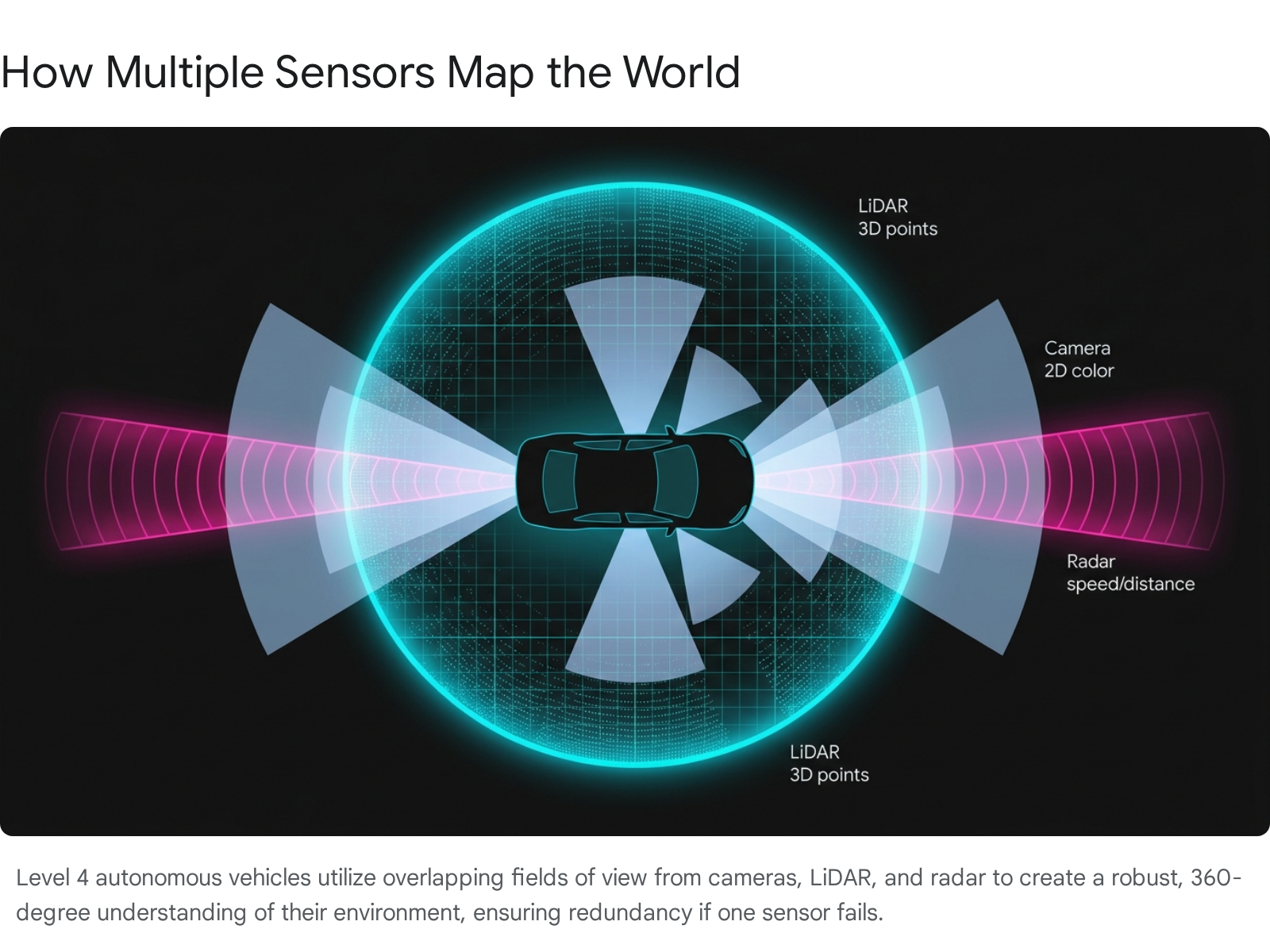
Before artificial intelligence can make a life-or-death driving decision, the vehicle must digitally reconstruct its physical environment in real time. Because no single piece of hardware is perfect in all environmental conditions, the industry standard for Level 4 autonomous vehicles - vehicles that can drive themselves under specific design domains without human intervention - is to utilize a diverse, redundant array of sensors 31011.
Cameras and Vision Systems
Cameras are the oldest, most ubiquitous, and most intuitive automotive sensors, functioning fundamentally like the human eye. They capture high-resolution, two-dimensional color imagery, making them the only sensor capable of reading the text on traffic signs, distinguishing the color states of a traffic light, or interpreting faded lane markings on asphalt 12. They are highly cost-effective and relatively lightweight, allowing manufacturers to embed them seamlessly around the vehicle 3.
However, because traditional frame-based cameras rely on ambient light, they suffer heavily in low-light conditions, face severe blinding glare from direct sunlight or wet roads, and lack native depth perception 313. Determining the precise distance of an object from a flat 2D image requires complex, computationally heavy neural networks to estimate depth via stereoscopic vision or monocular temporal cues 3.
To overcome the limitations of traditional frame-based cameras - which struggle with a limited dynamic range of roughly 60 to 95 decibels - researchers are increasingly exploring neuromorphic, event-based cameras 4. Inspired by biological nervous systems, event-based cameras do not capture full images at a set frame rate; instead, individual pixels independently report changes in light intensity 4. This results in an incredibly high dynamic range, virtual immunity to motion blur during high-speed maneuvers, and data processing latencies measured in microseconds, making them highly suited for split-second hazard detection 4.
LiDAR: Light Detection and Ranging
LiDAR acts as the vehicle's ultimate spatial anchor. It operates by firing hundreds of thousands to millions of laser pulses per second into the environment and measuring the exact nanosecond it takes for the light to bounce back to the sensor 31215. This "time-of-flight" calculation allows the sensor to construct a hyper-accurate, 360-degree, three-dimensional "point cloud" of the surrounding world, offering millimeter-level depth resolution at ranges up to several hundred meters 31516.
Because LiDAR provides its own light source, it functions flawlessly in pitch-black darkness and is largely immune to the sudden lighting changes that blind optical cameras 15. It is the undisputed gold standard for generating the precise 3D bounding boxes required for object avoidance. The primary downsides of LiDAR have historically been its prohibitive expense - though costs are rapidly falling toward price points below three hundred dollars for mass penetration - its mechanical complexity, and its vulnerability to severe weather 1516. Because LiDAR relies on the optical spectrum, heavy snow, thick fog, or torrential rain can scatter the laser beams, severely degrading the point cloud 1115.
RADAR: Radio Detection and Ranging
Unlike cameras and LiDAR, which are fundamentally optical sensors, radar utilizes electromagnetic radio waves 315. This physical difference grants radar an essential "all-weather" superpower: radio waves easily penetrate fog, heavy rain, snowdrifts, and dust storms that would otherwise blind the vehicle's other systems 312.
Furthermore, radar is uniquely adept at detecting the exact velocity of moving objects instantaneously by leveraging the Doppler effect 312. While a camera or LiDAR must compare multiple frames over time to infer how fast an object is moving, radar knows the object's speed the moment the radio wave bounces back 3. This makes radar the default, foundational sensor for safety-critical systems like adaptive cruise control and automatic emergency braking 1216.
The primary limitation of traditional automotive radar is its exceptionally low spatial resolution. While a radar system knows an object is one hundred meters away and traveling toward the vehicle at forty miles per hour, the sensor struggles to distinguish the exact shape of the object. It cannot easily differentiate a stationary bicycle from a metal signpost, or tell if a radar return is a stopped fire truck or a metallic bridge overpass 31215. The raw data from radar requires significant signal processing, including thresholding to filter weak signals and Fast Fourier Transforms (FFT) to accurately interpret distance and motion amidst a sea of background electromagnetic clutter 17.
Supporting Sensors: Ultrasonic and Inertial Measurement
To round out the perception suite, vehicles utilize ultrasonic sensors and Inertial Measurement Units (IMUs). Ultrasonic sensors emit high-frequency sound waves to detect objects at very close ranges, making them highly effective for low-speed parking maneuvers and blind-spot monitoring, though they are practically useless beyond a few feet 35. The IMU, meanwhile, measures the vehicle's specific force and angular rate. Pumping data out at extremely high frequencies exceeding 100 Hertz, the IMU allows the vehicle's computer to calculate dead reckoning - understanding exactly how the vehicle is moving and tilting through space even if GPS signals drop out or cameras are temporarily blinded 53.
Sensor Suite Comparison
| Sensor Type | Primary Output Mechanism | Depth Perception | Velocity Tracking | Weather Resilience | Lighting Dependence |
|---|---|---|---|---|---|
| Camera (Vision) | 2D RGB Pixel Arrays | Poor (Requires heavy AI estimation) | Poor (Inferred across multiple frames) | Poor (Blinded by glare, dirt, heavy rain) | High (Requires ambient light) |
| LiDAR | 3D Laser Point Clouds | Excellent (Millimeter accuracy) | Moderate (Inferred across sequential scans) | Moderate (Scattered by dense fog or snow) | None (Generates its own light pulses) |
| RADAR | Radio Wave Reflections | Good (Highly accurate distance metrics) | Excellent (Native Doppler effect measurement) | Excellent (Penetrates fog, rain, and snow) | None (Unaffected by ambient light) |
| Ultrasonic | High-Frequency Sound | Good (Centimeter accuracy at close range) | Poor (Only useful at very low speeds) | Moderate (Can be blocked by thick ice/mud) | None (Acoustic-based sensing) |
Data synthesized from comprehensive sensor evaluations. 310121516
Making Sense of the Noise: The Science of Sensor Fusion
Because every hardware sensor possesses fundamental physical blind spots, autonomous vehicle systems must mathematically combine their data streams to achieve situational awareness - a highly complex computational process known as sensor fusion 319. If a camera's vision is totally obscured by the glare of a setting sun, the radar can still detect the braking car ahead. If a radar confuses a metallic bridge joint for a dangerous obstacle, the high-resolution LiDAR can confirm that the physical roadway is clear 116.
However, fusing raw data from vastly different formats - stitching together two-dimensional pixels, three-dimensional point clouds, and radio wave frequency shifts - is a massive mathematical and computational challenge. Autonomous vehicle engineers generally architect their software to execute fusion at one of three distinct stages in the pipeline.
Late Fusion (Object-Level Integration)
In a late fusion architecture, each sensor processes its data entirely independently through its own algorithms before any merging occurs. The camera runs its own convolutional neural network to identify a "pedestrian," while the LiDAR runs a separate algorithm to identify a "3D cylindrical obstacle," and the radar detects a "moving mass." The system's central computer then compares these final, high-level outputs and merges them to make a decision 197.
This approach is highly modular and exceptionally fault-tolerant; if the camera system crashes or the lens is shattered, the LiDAR and radar pipelines continue to function normally, allowing the vehicle to pull over safely 19. Furthermore, it is computationally efficient because the central processor only deals with simple bounding boxes rather than millions of raw data points 19. However, the fatal flaw of late fusion is its lack of synergy. Because the sensors do not share raw data early in the process, the neural networks cannot leverage subtle cross-sensor clues. If an object is partially obscured and neither the camera nor the LiDAR is confident enough to flag it independently, the late fusion system might completely miss a hazard that could have been identified if the weak signals were combined 198.
Early Fusion (Data-Level Integration)
Early fusion takes the exact opposite approach. The raw, unprocessed data from all sensors is mathematically merged before any artificial intelligence processing occurs. For instance, the exact spatial coordinates of raw LiDAR points are projected directly onto the raw RGB pixels of the camera feed, creating an incredibly dense, information-rich, multi-dimensional dataset 1978.
This fused dataset is then fed into a single, massive neural network. The primary advantage of early fusion is that it preserves the richest possible information, allowing the deep learning model to find profound, non-obvious correlations between the different modalities that human engineers might never explicitly code 7. However, early fusion is notoriously difficult to implement. It requires exorbitant computational power to process the massive combined data structures 196. More critically, it is hypersensitive to physical misalignment. If a camera shifts by a fraction of a millimeter due to a pothole strike, the projected LiDAR points will misalign with the pixels, entirely corrupting the neural network's input data 197.
Mid-Level Fusion (Feature-Level Integration)
Mid-level, or feature-level, fusion has rapidly emerged as the modern industry standard, effectively bridging the gap between the extremes of early and late fusion. In this architecture, raw data is initially fed into separate, modality-specific neural network "backbones." These backbones do not attempt to identify final objects; instead, they extract high-level abstract "features" - mathematical representations of shapes, textures, and depths 78.
These intermediate features are then merged into a unified space, most commonly a simulated top-down "Bird's-Eye View" (BEV) of the vehicle and its surroundings 7823. By utilizing advanced attention mechanisms and token-based alignment networks, mid-level fusion allows the system to dynamically weigh the importance of different sensors depending on the context 67. If the camera features become noisy due to rain, the neural network learns to automatically shift its "attention" to the radar and LiDAR features within the Bird's-Eye View space, offering deep AI correlation without the brittle vulnerability of raw early fusion 7.
When the World Blurs: Weather and Physical Limitations
Despite the staggering processing power of modern deep learning models, autonomous vehicles remain strictly bound by the uncompromising laws of physics. The most robust perception systems can gracefully degrade or outright fail when exposed to severe weather, a reality that continually frustrates the industry's push for full, unconstrained Level 5 autonomy - the theoretical ability to drive anywhere, under any condition, without human oversight.
When Advanced Driver Assistance Systems (ADAS) or commercial robotaxis unexpectedly disengage, it is rarely due to an underlying software glitch; it is predominantly caused by the physical occlusion or degradation of the sensor suite. In heavy fog, blizzards, or torrential monsoon rains, airborne water droplets and ice crystals are roughly the same physical size as the near-infrared wavelengths of light emitted by LiDAR units and captured by automotive cameras. This physical reality triggers a phenomenon known as "Mie scattering," where the light waves bounce randomly off the suspended moisture rather than reflecting off the physical road environment 9. This scattering effectively blinds optical sensors, causing reliable detection ranges to plummet by 50 to 90 percent 9.
Furthermore, physical occlusion remains a stubborn hardware challenge. Driving through winter conditions causes slush, road salt, and dirt to cake directly over camera lenses, radar fascias, and ultrasonic sensors 252610. Even a thin layer of ice over a sensor can drastically degrade detection capabilities. If a windshield camera is blocked by a snowdrift, critical safety systems like Lane-Keeping Assist and Automatic Emergency Braking (AEB) will simply shut down, as they lack the raw visual data required to map lane lines or calculate distances safely 525.
When severe weather degrades individual sensor performance, multi-sensor fusion algorithms often receive highly conflicting inputs. For example, if the radar penetrates a snowstorm and detects a clear road ahead, but the camera is blinded by glare and registers an impenetrable wall of white, the artificial intelligence must decide which sensor to trust. In these ambiguous situations, autonomous systems fall back on safety frameworks like the Safety of the Intended Functionality (SOTIF) standard. SOTIF dictates that the vehicle's operational universe is partitioned into known safe, known unsafe, unknown safe, and unknown unsafe scenarios 11. When sensor degradation pushes the vehicle into an unknown or known unsafe state, the system is programmed to abandon the mission and execute a "minimal risk condition" - which typically involves slowing down, activating hazard lights, and pulling over to the shoulder until visibility improves 2930.
These inherent vulnerabilities were laid bare during the spring of 2026. In March and April, roughly one hundred Baidu Apollo Go robotaxis simultaneously immobilized themselves across the city of Wuhan due to a sudden software and perception failure, snarling urban traffic and prompting local regulators to demand immediate safety reviews 112. Only weeks later, Waymo voluntarily recalled 672 vehicles from its American fleet after a software defect resulted in two autonomous cars striking low-height utility poles in Phoenix 112. Both high-profile incidents underscore a sobering reality: while artificial intelligence has largely mastered driving in optimal, sun-drenched conditions, navigating the unpredictable "long tail" of real-world edge cases remains a formidable scientific hurdle 32.
The Brain of the Machine: Modular Pipelines vs. End-to-End AI
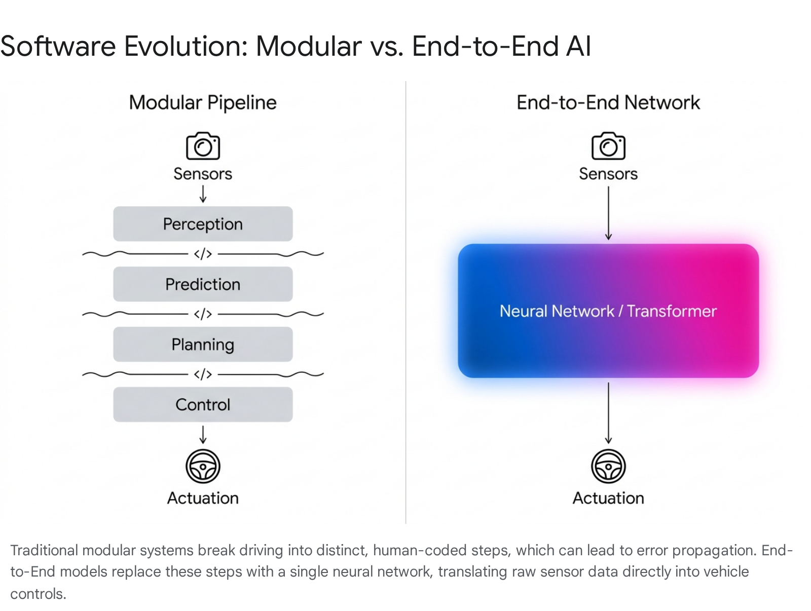
Once the perception system has digested the sensor data and fused it into a coherent snapshot of the environment, the vehicle's computer must decide what physical action to take next. Historically, this has been achieved through a rigid, "modular" software pipeline. Today, however, the global autonomous driving industry is undergoing a massive, highly debated paradigm shift toward "End-to-End" (E2E) deep learning architectures.
The Traditional Approach: The Modular Architecture
For the past decade, autonomous vehicle software was constructed much like an industrial assembly line. The infinitely complex task of driving was broken down into a sequence of discrete, highly specialized, and human-interpretable sub-tasks 333413.
The pipeline typically operated in four distinct stages. First, the Perception module would ingest sensor data to draw bounding boxes around pedestrians, map lane lines, and read traffic lights 3334. Second, the Prediction module would calculate the trajectory of those recognized objects, attempting to guess where a bicyclist might be in three seconds 3413. Third, the Planning module would ingest these predictions and run complex optimization algorithms to calculate a safe, comfortable trajectory for the ego-vehicle 3313. Finally, the Control module would translate that mathematical trajectory into physical electrical signals sent to the steering motor and brake calipers 3313.
The primary appeal of the modular architecture is its transparency. It is highly interpretable for human engineers. If an autonomous vehicle brakes too hard at an intersection, programmers can examine the logs, isolate the exact line of code in the Control module, and manually adjust the braking parameters 13.
However, the modular approach suffers from severe, inherent flaws. The most critical issue is "error propagation" 3313. Because the modules operate sequentially, a tiny mistake at the beginning of the pipeline magnifies as it moves down the line. If the Perception module misidentifies a partially obscured stop sign by just a few pixels, it passes incorrect data to the Prediction module, which calculates a flawed model, causing the Planning module to make a dangerous decision 33. Furthermore, the Planning and Control modules have historically been governed by hundreds of thousands of lines of explicitly written "if/then" heuristics 1438. It is fundamentally impossible for human engineers to write a specific line of code for every conceivable edge case, weather condition, and human behavior encountered on a physical road 14.
The Revolution: End-to-End (E2E) Neural Networks
End-to-end autonomous driving represents a radical, philosophical departure from the modular approach. Instead of breaking the driving task into discrete, human-coded steps, E2E systems utilize massive, unified deep neural networks. These networks ingest raw or lightly fused sensor data on one end, and directly output steering, braking, and acceleration commands on the other end 331438.
This architecture is often referred to in the industry as a "photon-to-control" model 38. The artificial intelligence is no longer taught explicit, human-defined traffic rules. Instead, it learns the underlying "physics" and intuition of driving by ingesting millions of hours of video footage and telemetry data from expert human drivers, utilizing imitation learning to map visual cues directly to physical actions 3339.
The transition to end-to-end learning has resulted in staggering performance leaps. Early, segmented E2E models, such as the groundbreaking UniAD framework introduced in early 2023, demonstrated that joint feature optimization across perception and planning could drastically reduce errors 2315. By late 2024, advanced E2E systems had achieved remarkable precision, reducing the "L2 distance" - the statistical margin of error between the AI's predicted driving trajectory and the optimal, safe human trajectory - from 1.03 meters down to a mere 0.22 meters 1542.
Despite these performance gains, E2E systems introduce a critical new vulnerability: the "black box" problem. Because there are no discrete, human-readable modules, it is incredibly difficult to achieve interpretability and pinpoint causality 333413. If an E2E-driven car makes a sudden, inexplicable swerve into an oncoming lane, safety engineers cannot easily open the code to determine exactly why the massive web of neural weights triggered that specific action, complicating regulatory approval and safety audits 3313.
The Great Industry Debate: Vision-Only vs. Multi-Sensor Fusion
The transition to new artificial intelligence architectures has catalyzed the most polarizing, high-stakes debate in the autonomous vehicle industry: Should a car rely solely on cameras to mimic human vision, or must it utilize a highly redundant array of LiDAR, radar, and cameras to ensure safety? This schism is not merely academic; it dictates billions of dollars in hardware investments, defines distinct commercialization strategies, and determines how vehicles interact with regulatory bodies.
The Waymo and Baidu Approach: Sensor Fusion and Redundancy
Companies operating commercial robotaxi services, predominantly Alphabet's Waymo in the United States and Baidu's Apollo Go in China, have steadfastly committed to the multi-sensor fusion approach. A modern Waymo vehicle, for instance, bristles with an overwhelming array of 29 high-definition cameras, 6 advanced radars, and 5 mechanical and solid-state LiDARs 104344. These sensors feed into advanced multimodal foundation models, such as Waymo's "EMMA" architecture 1544.
The philosophy behind this heavy hardware footprint is absolute redundancy. Proponents argue that to achieve "superhuman levels of safety" and operate without a human backup driver, mechanical redundancy is non-negotiable 43. If a camera is blinded by the setting sun, or if a neural network fails to recognize an oddly shaped truck trailer, the physical LiDAR point cloud and the radar returns act as an infallible safety net, physically detecting the object and initiating an emergency stop 44.
The primary drawbacks to this approach are hardware costs, manufacturing complexity, and scaling constraints. Integrating, powering, and perfectly calibrating dozens of highly sensitive lasers and radars is an absolute nightmare for automotive manufacturing at scale. Furthermore, these sensor-heavy systems have historically relied heavily on pre-mapped "High-Definition" (HD) maps, meaning the vehicles are strictly geofenced to areas that have been painstakingly digitally scanned by the company in advance 45. However, the cost barrier is rapidly eroding. In 2024, Baidu launched its sixth-generation robotaxi equipped with the Apollo ADFM (Autonomous Driving Foundation Model), bringing the total vehicle cost down 60 percent to roughly 200,000 yuan (approximately $27,600) 4648. This hardware optimization has allowed Baidu to scale aggressively; by late 2025, Baidu had completed an astounding 6 million autonomous rides across 10 Chinese cities, significantly outpacing Waymo's 1 million rides concentrated in just 3 US cities 116.
The Tesla Approach: Vision-Only End-to-End AI
Tesla, guided by CEO Elon Musk, has taken the exact opposite path. Arguing that expensive laser sensors are a crutch, Tesla has aggressively pursued a "vision-only" strategy, relying entirely on a suite of 8 optical cameras 154344.
The philosophy here is rooted in biological mimicry. Humans navigate the complexities of global roadways utilizing only two optical sensors (eyes) and a highly advanced neural network (the brain). Therefore, Tesla argues, an artificial intelligence equipped with 8 high-definition "eyes" providing 360-degree coverage, backed by massive computational power, should be capable of solving autonomy without the need for expensive, power-hungry lasers or radar 1338.
To achieve this, Tesla has spent years aggressively rewriting its software architecture to shed traditional human-coded rules. In 2021, the company introduced "HydraNets" - multi-task neural networks capable of executing dozens of perception tasks simultaneously from a shared visual backbone 50. By 2022, they added "Occupancy Networks" to computationally construct three-dimensional voxels of the world using only 2D camera feeds, mimicking the depth perception of LiDAR without the hardware 50. The culmination of this strategy occurred with the release of FSD v12 and v13 between 2024 and 2025, where Tesla finally deployed a true, end-to-end Vision Transformer 33839. In this update, the company deleted over 300,000 lines of explicit C++ control code, allowing the single neural network to map raw camera pixels directly to steering angles 38.
Tesla's ultimate competitive advantage is its massive data engine. Because its hardware suite is cheap enough to deploy on millions of consumer cars globally, Tesla collects billions of miles of real-world driving data, providing the gargantuan datasets necessary to train its end-to-end models 3844. However, the glaring drawback remains physics. Because Tesla's system relies entirely on the optical spectrum, it remains fundamentally susceptible to the same blinding glare, heavy fog, and optical illusions that plague human drivers, leading safety advocates to question whether true Level 5 autonomy is ever possible without redundant hardware 13644.
Comparing the Industry Leaders
| Metric | Waymo (Alphabet) | Baidu (Apollo Go) | Tesla (Full Self-Driving) |
|---|---|---|---|
| Primary Philosophy | Multi-Sensor Fusion + Absolute Redundancy | Sensor Fusion + Large Foundation Models | Vision-Only + End-to-End AI Scaling |
| Core Hardware Suite | 29 Cameras, 5 LiDARs, 6 Radars | Cameras, Advanced LiDAR, Radar | 8 Optical Cameras |
| Target Autonomy Level | Level 4 (Geofenced Driverless Robotaxi) | Level 4 (Geofenced Driverless Robotaxi) | Level 2 / Conditional L3 (Supervised Consumer EV) |
| Data Scaling Strategy | High-fidelity simulation & targeted fleet data | Heavy simulation & state-subsidized urban rollout | Millions of customer vehicles globally |
| Core AI Architecture | EMMA (Multimodal Foundation Model) | Apollo ADFM (L4 Large Model) | Single Vision Transformer (v12/v13) |
Data synthesized from corporate technical disclosures and industry benchmarks. 13101139154344464816
Calculating Safety: Split-Second Decisions on the Road
Beneath the overarching deep learning architectures, autonomous vehicles still require rigorous, mathematically provable safety frameworks to execute maneuvers like emergency braking. The industry frequently utilizes deterministic models, such as Responsibility-Sensitive Safety (RSS), to formalize the bounds of safe behavior 11.
Consider a scenario where an autonomous vehicle is trailing a lead vehicle, and a pedestrian - perhaps a child - suddenly darts into the street, forcing the lead vehicle to slam on its brakes. The perception system instantly detects the rapid deceleration. However, calculating the safe response is not as simple as merely hitting the brakes. The vehicle's computer must continuously calculate complex physics equations that account for its own current velocity, the deceleration rate of the lead vehicle, road friction, and its own exact response time constraint, often denoted mathematically as ρ 11.
The system must determine if a collision is mathematically unavoidable during the response time interval ρ, or if the ego-vehicle's superior braking capabilities can bring it to a halt just inches behind the lead vehicle's resting position 11. If the physics engine determines that a longitudinal collision is inevitable despite maximal braking, the system must instantly query the lateral perception space - checking blind spots and oncoming lanes - to determine if an evasive swerve is mathematically safer than a direct rear-end collision. Balancing these calculations to ensure maximum safety without causing the vehicle to drive so timidly that it paralyzes urban traffic flow is one of the most delicate tuning tasks for autonomous engineers 1152.
Anticipating the Unseen: The Rise of Generative World Models
If End-to-End neural networks represent how a car reacts to the present moment, World Models represent how a car imagines the future.
Human drivers do not just react to what they can physically see; they possess an innate, commonsense understanding of physics, object permanence, and causality. If a bouncing ball rolls into the street from behind a parked van, a human driver intuitively anticipates that a child might be running closely behind it, slowing down before the child even becomes visible. For years, artificial intelligence severely lacked this contextual, counterfactual spatial reasoning 3054.
To bridge this critical intelligence gap, the autonomous driving industry has pivoted heavily toward the development of generative World Models 55. Borrowing underlying architectures from Large Language Models (LLMs) and advanced video generation AI, a world model is a neural network trained to deeply understand the physical laws and dynamics of a driving environment 5556.
These models are fundamentally redefining how perception systems handle object tracking and memory. Instead of merely identifying a pedestrian in the current camera frame, the world model constructs dynamic 3D "occupancy grids" that forecast the exact spatial coordinates that the pedestrian will occupy three to five seconds into the future 235456. If the vehicle's sensors briefly lose sight of the pedestrian due to an occlusion - such as a large truck passing between the car and the crosswalk - the world model's temporal memory and predictive physics allow the vehicle to "know" the pedestrian is still moving behind the truck, preventing the car from accelerating into the crosswalk blindly 54.
Furthermore, world models serve as the ultimate simulation and validation engine for the industry. Systems like Wayve's "GAIA-1," which was scaled to an astounding 9 billion parameters in late 2023, utilize video, text, and action prompts to synthesize highly realistic, controllable driving futures 55. Waymo has developed a similar platform built upon Google DeepMind's "Genie 3" architecture, which generates hyper-realistic, multi-sensor simulations - including perfectly synthesized LiDAR point clouds and camera feeds 17.
These generative models can essentially hallucinate exceedingly rare "long-tail" events that are too dangerous or rare to capture in reality - such as a tornado crossing a highway, or a vehicle driving the wrong way down a one-way street 17. By allowing the vehicle's driving algorithms to practice navigating these mathematically generated realities, world models provide an elegant solution to the "black box" problem of end-to-end systems, enabling engineers to rigorously test and score safety behaviors without ever putting human lives at risk on physical roads 17.
The Commercial Reality: Scaling the Robotaxi Fleet
The culmination of these staggering perception technologies is currently playing out on the streets of major global cities, where the commercial reality of autonomous driving is accelerating rapidly. The geopolitical race to deploy these technologies highlights differing regulatory philosophies.
In China, the rollout of commercial robotaxis is heavily supported by municipal governments that actively build smart-road infrastructure and provide clear, top-down regulatory frameworks 12. This support has allowed Baidu's Apollo Go to scale aggressively, deploying thousands of highly capable, affordable Level 4 vehicles across complex urban centers like Wuhan and Beijing 12. Conversely, the United States operates under a more fragmented regulatory landscape, where individual states dictate deployment rules 1. Waymo has navigated this by meticulously rolling out highly redundant, expensive hardware platforms in targeted, geofenced cities like Phoenix, Los Angeles, and San Francisco, prioritizing verifiable safety metrics - such as an 85% reduction in serious injury accidents - over raw geographic expansion 111.
Bottom line
The real-time perception pipeline of an autonomous vehicle is a modern engineering marvel, tasked with ingesting billions of data points, fusing them into a coherent spatial reality, and executing life-saving physical actions - all within a merciless 100-millisecond latency budget. While the industry remains deeply ideologically divided on hardware - pitting Tesla's highly scalable, vision-only approach against the robust, sensor-heavy redundancy platforms of Waymo and Baidu - both sides are rapidly converging on a future dominated by unified End-to-End neural networks and highly predictive, generative World Models. However, the recurring safety incidents of 2026 and the fundamental limits of sensor physics in severe weather serve as stark reminders that mastering the unpredictable "long tail" of real-world edge cases remains a stubborn, monumental barrier to achieving ubiquitous, unconstrained autonomy.